Showing posts with label Indian tourism. Show all posts

Monday, February 5, 2018

Shimla


Shimla  or Simla is the capital of the state of Himachal Pradesh in India. It is a very popular holiday-retreat during the summer months and is well-known for its Victorian architecture, which is reflected in certain areas of the Mall and The Ridge. It is also a famous holiday spot for honeymoon. 


Shimla's cool climate is the precise reason why it is such a popular summer retreat. Located at an altitude of approximately 2200m above sea level, the region has a hilly terrain and is covered by dense evergreen forests. A few visitors choose to visit Shimla during spring or autumn, when the place is less crowded and the views are too spectacular for words.  

By train

The nearest broad gauge head is at Kalka - a four- to seven-hour journey from Delhi. After that, take the mountain train from Kalka to Shimla. This railway track has recently been granted the status of a UNESCO World Heritage Site. The view is stunning, with the line passing through an amazing 103 tunnels. The fastest way to get to Kalka is to catch the Shatabdi Express, which departs early morning from the New Delhi Railway Station, arriving at Kalka four hours later. A detailed list of trains between Delhi, Kalka and Shimla is available at  and You can also choose to get off at Chandigarh (en-route to Kalka), and catch a taxi from there. 


Note that while the Shivalik Deluxe Express can be reserved 60 days in advance like most Indian trains, most of the other mountain trains can only be reserved 30 days before journey date. Passengers on the Shivalik Deluxe Express are served meals on the train--breakfast on the way to Simla, dinner on the way down. 

By plane

Shimla has its own airport at a place known as Jubbarhatti (IATA code:SLV), 22 km away, a distance which, owing to the difficulties of the mountainous terrain, poor condition of road surfaces, and the increasing traffic congestion, often takes hours to traverse by car from Shimla. The airport has severe limitations imposed both by its elevation at 1,546 metres above sea level and by the shortness of its single runway (1,230 m) which ends in precipice at either end, and it can accommodate only turboprop Dornier aircraft; jets such as Airbus A310, 320s and Boeing 737s can all land at the larger Chandigarh (IATA code:IXC) airport. 
The Chandigarh Airport, located at a distance of 120 km from Shimla along far better roads and at an elevation of only 308 metres above sea level, offers far better flight options. Major airlines including Indian  Jet Airways and Air Deccan operate flights to Delhi, Jammu, and Mumbai. Most of the flights to Mumbai require a stop-over in Delhi. Tip, confirm the flights till the very last moment, bad weather often delays flights during the winter fog. 
After landing at the airport, take a pre-paid taxi to minimize hassle. Chandigarh is a good four-hour drive away, so stop for a bite on the Kalka-Shimla highway.


By Taxi

  • Savaari.com (Savaari Car Rentals), 0 90 4545 0000 (info@savaari.com), . India's largest inter-city and local cab booking service who have a presence in 98 cities across the country. You can book a cab in Shimla either on their website or through their Call center.
  • Shimla taxi (shimlataxi),  Local service provider in Shimla. They support website bookings.
  • Himachal taxi (himachaltaxi). Another local service provider in Shimla. You can make enquiries through their website or call their customer service number

Wednesday, January 17, 2018

Nainital


Nainital  is a popular hill station in the Indian state of Uttarakhand and headquarters of Nainital district in the Kumaon foothills of the outer Himalayas. Situated at an altitude of 2,084 metres (6,837 ft) above sea level, Nainital is set in a valley containing a pear-shaped lake, approximately two miles in circumference, and surrounded by mountains, of which the highest are Naina (2,615 m (8,579 ft)) on the north, Deopatha (2,438 m (7,999 ft)) on the west, and Ayarpatha (2,278 m (7,474 ft)) on the south. From the tops of the higher peaks, "magnificent views can be obtained of the vast plain to the south, or of the mass of tangled ridges lying north, bounded by the great snowy range which forms the central axis of the Himalayas.


Famous Landmarks

  • Nainital Lake
  • Naini Peak
  • Tiffin Top
  • Snowview Point
  • Gurney House
  • Naina Devi Temple
  • Cave Garden
  • Sat Tal
  • Hanumangarhi
  • Mall Road
  • Pt. G.B. Pant High Altitude Zoo, Nainital


Monday, January 15, 2018

Ooty (Beautiful hill station in india)


Ooty features a subtropical highland climate (Cwb) under Köppen climate classification. Despite its location in the tropics, in contrast with most of South India, Ooty generally features mild conditions throughout the year. However, night time in the months of January and February is typically cold. Generally, the town appears to be eternally stuck in the spring season. Temperatures are relatively consistent throughout the year; with average high temperatures ranging from about 17–20 °C (63–68 °F) and average low temperatures between approximately 5–12 °C (41–54 °F).


The highest temperature ever recorded in Ooty was 25 °C (77 °F), which by South Asian standards is uncharacteristically low for an all-time record high temperature. The rainy season in Ooty is generally cool and windy with high humidity. The wind chill may fall to as low as 5 °C (41 °F) during the day time. Wind is always high throughout the year. The lowest temperature was −2 °C (28 °F). The city sees on average about 125 cm (49 in) of precipitation annually, with a marked drier season from December through March.

Places of interest

Ooty is situated in the Nilgiri Biosphere Reserve. Many of the forested areas and water bodies are off-limits to most visitors to protect this fragile ecosystem. Some areas of the Biosphere Reserve have been earmarked for tourism development, and steps are being undertaken to open these areas to visitors whilst conserving the area. It is situated at an altitude of 2,240 metres (7,350 feet) above sea level.
Gardens and parks

Botanical Garden in Ooty

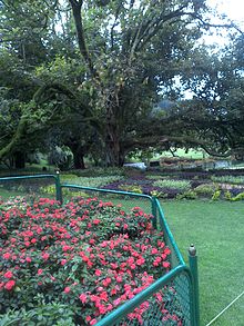
The Government Botanical Garden
The Government rose garden (formerly Centenary Rose Park)[ is the largest rose garden in India.It is situated on the slopes of the Elk Hill in Vijayanagaram of Ooty town. at an altitude of 2200 meters. Today this garden has one of the largest collection of roses in the country with more than 20,000 varieties of roses of 2,800 cultivars. The collection include hybrid tea roses, Miniature Roses, Polyanthas, Papagena, Floribunda, Ramblers, Yakimour and roses of unusual colours like black and green.


Xerochrysum bracteatum - Everlasting flower from Ooty
The 22-acre (89,000 m2) Ooty Botanical Gardens was laid out in 1847 and is maintained by the Government of Tamil Nadu. The Botanical Garden is lush, green, and well-maintained. A flower show along with an exhibition of rare plant species is held every May. The gardens have around a thousand species, both exotic and indigenous, of plants, shrubs, ferns, trees, herbal and bonsai plants.[ The garden has a 20-million-year-old fossilised tree.

Deer Park is located on the edge of Ooty Lake. It is the highest altitude zoo in India aside from the zoo in Nainital, Uttarakhand. This park was formed to house a number of species of deer and animals.
Lakes and dams

Ooty Lake
Ooty lake covers an area of 65 acres.The boat house established alongside the lake, which offers boating facilities to tourists, is a major tourist attraction in Ooty. It was constructed in 1824 by John Sullivan, the first collector of Ooty. The lake was formed by damming the mountain streams flowing down Ooty valley. The lake is set among groves of Eucalyptus trees with a railway line running along one bank. During summer season in May, boat races and boat pageantry are organised for two days at the lake.

Boating in Pykara Lake in Ooty
Pykara is a river located 19 km from Ooty.[ The Pykara is considered very sacred by the Todas. The Pykara river rises at Mukurthi peak and passes through hilly tract, generally keeping to North and turns to West after reaching the Plateau's edge. The river flows through a series of cascades; and the last two falls of 55 meters and 61 meters are known as Pykara falls. The falls are approximately 6 km from the bridge on the main road. A boat house by the Pykara falls and dam is added attractions to the tourists. Kamaraj Sagar Dam (also known as Sandynalla reservoir)is located at a distance of 10 km from the Ooty bus stand.


 It is a picnic spot and a film shooting spot on the slopes of the Wenlock Downs.The various tourist activities the dam include fishing and studying nature and environment. Parsons Valley Reservoir is the primary water source for the town and is mainly in a reserved forest and is thus largely off-limits to visitors. Emerald Lake, Avalanche Lake and Porthimund Lake are other lakes in the region.
        Reserve forests

The Pine Forest in Ooty

Tiger Safari in Mudumalai Tiger Reserve

Mukurthi National Park
Doddabetta is the highest peak (2,623 m) in the Nilgiris, about 10 km from Ooty. It lies at the junction of the Western and Eastern Ghats surrounded by dense Sholas. Pine forests situated between Ooty and Thalakunda is a small downhill region where pine trees are arranged in an orderly fashion. Wenlock Downs is a grassland area typical of the original bioscape of the Nilgiris with gently undulating hills. Mudumalai National Park and tiger reserve lies on the north western side of the Nilgiri Hills.

 The sanctuary is divided into 5 ranges - Masinagudi, Thepakadu, Mudumalai, Kargudi and Nellakota. Here one can often spot herds of endangered Indian elephants, vulnerable gaur, and chital. The sanctuary is a haven for Bengal tigers and Indian leopards and other threatened species. There are at least 266 species of birds in the sanctuary, including critically endangered species like the Indian white-rumped vulture and the long-billed vulture. Mukurthi National Park is a 78.46 km2 protected area located in the south-eastern corner of the Nilgiris Plateau west of Ooty. The park was created to protect its keystone species, the Nilgiri tahr.The Western Ghats, Nilgiri Sub-Cluster (6,000 km2 (2,300 sq mi)), including all of Mudumalai National Park, is under consideration by the UNESCO World Heritage Committee for selection as a World Heritage Site.
Tribal huts and museum

Toda Hut
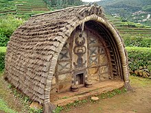
There are a few Toda huts on the hills above Botanical Garden, where Todas still dwell. There are other Toda settlements in the area, notably Kandal Mund near Old Ooty. Although many Toda have abandoned their traditional distinctive huts for concrete houses, a movement is now afoot to build tradition barrel-vaulted huts and during the last decade forty new huts have been built and many Toda sacred dairies renovated.

The Tribal Museum is part of the campus of Tribal Research Centre which is in Muthorai Palada (10 km from Ooty town). It is home to rare artefacts and photographs of tribal groups of Tamil Nadu as well as Andaman and Nicobar Islands and anthropological and archaeological primitive human culture and heritage. The Tribal Museum also displays houses belonging to Toda, Kota, Paniya, Kurumba and Kanikarans.
Nilgiri Mountain Railway
The Nilgiri Mountain Railway was built by the British in 1908, and was initially operated by the Madras Railway Company. The railway still relies on its fleet of steam locomotives.NMR comes under the jurisdiction of the newly formed Salem Division. In July 2005, UNESCO added the Nilgiri Mountain Railway as an extension to the World Heritage Site of Darjeeling Himalayan Railway, the site then became known as "Mountain Railways of India."[ after it satisfied the necessary criteria, thus forcing abandonment of the modernisation plans. For the past several years diesel locomotives have taken over from steam on the section between Coonoor and Udagamandalam. Local people and tourists have led a demand for steam locos to once again haul this section.
Historical buildings

Fernhills palace
Stone House is the first bungalow constructed in Ooty. It was built by John Sullivan and was called as Kal Bangala by the tribals (Kal means stone in local tribal language). John Sullivan started building Stone House in 1822, acquiring land from the Todas at one rupee an acre.Today, it is the official residence for the principal of the Government Arts College, Ooty.

St Stephen's Church is located on the road to Mysore in Ooty, in the state of Tamil Nadu, India. It is one of the oldest churches in the Nilgiris district. The church dates back to the 19th century. Stephen Rumbold Lushington, the then governor of Madras, who keenly felt the need for a cathedral exclusively for the British, in Ooty, laid the foundation for the church on 23 April 1829, to coincide with the birthday of King George IV. St Stephen's Church was consecrated by John Matthias Turner, Bishop of Calcutta, on 5 November 1830. It was thrown open to public communion on Easter Sunday 3 April 1831. It came under the Church of South India in 1947. The architect in charge was John James Underwood, Captain, Madras Regiment.

In 1882 the rules and game of snooker were first drafted and codified in the "Ooty Club". The club still houses the billiards table that was used.


The nearest airport is Coimbatore, around 96 km (60 mi) away and Major International Airport is Bengaluru (Kempegowda International Airport 273 km away). Ooty has three helipads, one at Theettukal and two at Kodanad. The Theettukal helipad was approved by Airports Authority of India for defence and VIP services. Pawan Hans was supposed to start its service with Bell 407, but being present amidst farmland, dislocation of the farm animals there has put the operations on hold for commercial activities.


Thursday, January 11, 2018

House Boat in Kerala

A houseboat (different from boathouse, which is a shed for storing boats) is a boat that has been designed or modified to be used primarily as a home. Some houseboats are not motorized, because they are usually moored, kept stationary at a fixed point and often tethered to land to provide utilities. However, many are capable of operation under their own power. Float house is a Canadian and American term for a house on a float (raft), a rough house may be called a shanty boat. In Western countries, houseboats tend to be either owned privately or rented out to holiday-goers, and on some canals in Europe, people dwell in houseboats all year round. Examples of this include, but are not limited to, Amsterdam, London, and Paris.


Tourism in Kumarakom largely revolves -around the backwaters of the Vembanad Lake. Several luxury and budget resorts lined up on the shores of the lake provide tourists with facilities for boating, yachting and fishing, with panoramic views of the lake. The other major attraction is the Bird Sanctuary, which is open from 6 am to 6 pm and can be visited by canoes arranged by local fishermen at the entrance to the sanctuary. A two-hour rowing canoe trip is quite cheap, and is best undertaken in the evening or early morning to avoid the afternoon sun.

Furthermore, the Aruvikkuzhi Waterfall and its surrounding rubber plantation are a photographer's delight. There is also the Bay Island Drift Museum near the Kumarakom beach for history lovers, open from 10 am – 5 pm on Tuesdays – Saturdays and from 11.30 am – 5 pm on Sundays.


 Inside House Boat

Saturday, January 6, 2018

Mysore Palace


Ambavilas Palace, otherwise famous as the Mysore Palace, is a historical palace and a royal residence at Mysore in the southern Karnataka state of India. It is the official residence of the Wadiyar dynasty and the seat of the Kingdom of Mysore. The palace is in the centre of Mysore, and faces the Chamundi Hills eastward. Mysore is commonly described as the 'City of Palaces', and there are seven palaces including of this; however, Mysore Palace refers specifically to this one within the Old Fort.


The land on which the palace now stands was originally known as puragiri (literally, citadel), and is now known as the Old Fort. Yaduraya built the first palace inside the Old Fort in the 14th century, which was demolished and constructed multiple times. The current structure was constructed between 1897 and 1912, after the Old Palace was burnt ablaze.

Mysore Palace is now one of the most famous tourist attractions in India, after the Taj Mahal, with more than 6 million annual visitors.

Visitor information

The palace is 1.8 km (1.12 miles) from the central railway station to its west, 1.4 km (roughly 0.8 miles) from suburb bus-stand to its north-east, and 9.5 km (around 6 miles) from Mysore Airport, and in a small portion in its backyard is the city bus stand. The domestic airport is directly connected to the international airports of Bangalore, Chennai, Trivandrum, Hyderabad, Mangalore, and Bombay. The city is connected through the state highway SH-17.
  • The Palace Light Illumination is on Sundays and all public holidays between 7 and 7:45 in the evening, and on all ten days during the Dasara.
  • Sound and light programmes are arranged on all days between the same time, 7 and 7:45 in the evenings, except on Sundays and public holidays.
The Old Fort of the palace stands open from morning 10 to night 8 and is free of cost. Entry to the palace buildings is between 11 in the morning and 3 in the afternoon, under tight security. Two squads, one police and one paramilitary, stand guard during the day, and two more during night. Children below seven are free to enter the palace, while those between seven and twelve are charged Rs 25 per head. For adults, tickets are available for Rs. 40. Price of admission for foreign tourists is INR 200. Footwear are to be removed before entering the palace complexes.

A major issue for visitors is the frequent extortion of bribes from visitors and tourists from corrupt Police and Palace Guards. Several scams have been reported, like guards' befriending visitors, offering to take them to special places, and extort money. Visitors have reported other scams perpetrated by corrupt officials which include demands to produce tickets and further requesting bribes.


Taj Mahal


 The Taj Mahal is an ivory-white marble mausoleum on the south bank of the Yamuna river in the Indian city of Agra. It was commissioned in 1632 by the Mughal emperor, Shah Jahan, to house the tomb of his favourite wife, Mumtaz Mahal.

The Taj Mahal attracts a large number of tourists. UNESCO documented more than 2 million visitors in 2001,which had increased to about 7–8 million in 2014.A two-tier pricing system is in place, with a significantly lower entrance fee for Indian citizens and a more expensive one for foreigners. Most tourists visit in the cooler months of October, November and February. Polluting traffic is not allowed near the complex and tourists must either walk from parking lots or catch an electric bus. The Khawasspuras (northern courtyards) are currently being restored for use as a new visitor centre.

The small town to the south of the Taj, known as Taj Ganji or Mumtazabad, was originally constructed with caravanserais, bazaars and markets to serve the needs of visitors and workmen. Lists of recommended travel destinations often feature the Taj Mahal, which also appears in several listings of seven wonders of the modern world, including the recently announced New Seven Wonders of the World, a recent poll with 100 million votes.


The grounds are open from 06:00 to 19:00 weekdays, except for Friday when the complex is open for prayers at the mosque between 12:00 and 14:00. The complex is open for night viewing on the day of the full moon and two days before and after,excluding Fridays and the month of Ramadan. For security reasons only five items—water in transparent bottles, small video cameras, still cameras, mobile phones and small ladies' purses—are allowed inside the Taj Mahal.